
Offshore anglers commonly use oceanographic data, such as plankton concentrations and ocean altimetry, to help them find fish. Over the past 30 years, a variety of companies—such as ROFFS, Terrafin SST-View and Hilton’s Realtime Navigator—has delivered these services as well as forecasts and analyses. Early data first came by fax, and later online and via apps, such as Mazu SportFishing.
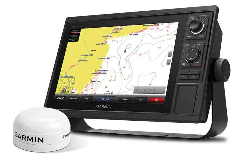
This past summer, SiriusXM announced that it now can feed eight specific data features, in addition to weather, directly to select onboard Garmin electronics displays, using a new Garmin satellite antenna—at distances up to 150 miles offshore, well out of cellular range. They call the new service Fish Mapping.
“Knowing that anglers were actively using our service for temperature breaks and weather, we felt there was so much more that we could offer,” says Geoff Leech, SiriusXM director of marine partnerships. “There are a lot of great services out there, and each has its niche. Our reports are less custom. They span the SiriusXM coverage area, so you can get a report right at the boat anytime.”
First to Market
SiriusXM has worked with all the major electronics manufacturers to deliver its weather service, but Garmin jumped at the chance to partner first on the Fish Mapping project. “We’ve been working with SiriusXM for a long time now” on weather antennas says David Dunn, Garmin director of sales and marketing. “They’ve really figured out a way to put some science behind all this data. Satellites are becoming capable of doing so much more.”
Leech says SiriusXM has continually looked for ways to innovate and evolve, and its research led to Maxar Technologies, a satellite company that provides imagery for Google maps. He says Maxar’s oceanographers also work with commercial fisheries and government agencies around the world.
“When Fish Mapping first came out, I was leery about it,” says Greg Montgomery, owner of We R Marine Electronics in Forked River, New Jersey. “I recently took a boat to Florida from New Jersey. We were able to fish two of five days, and then fish once we got down there. When I came out of the first inlet, I used Fish Mapping to get an area for wahoo. We did catch a wahoo. I was kind of amazed.”
Montgomery says he knows lightning can strike more than once, so he used the service again to target mahi, “and right where they said it should be producing, it happened again.”
He used a feature called Fishing Recommendations, which shows areas Maxar has recommended for finding specific types of gamefish. SiriusXM focuses on six species right now—bluefin tuna, blue marlin, mahi, swordfish, wahoo and yellowfin tuna—with more to come soon.
Where and When
In addition to Fishing Recommendations, which is updated twice a week, the new service provides these seven features:
Weed Lines: NASA satellites show reflectivity in the water, allowing scientists to draw contours around weed lines. You can view a loop of the past three days. (Updates happen every 24 hours.) Cloud cover can obscure imagery.
Sea Surface Height Anomaly: Sea-level changes based on conditions. The service shows height information in inches, updated every 24 hours. For instance, 1.96 means a downwelling, where fish activity would diminish. The number 19.68 (inches) would indicate an upwelling, which brings nutrients up to the surface, attracting bait and gamefish.
Sea Surface Temperature Contours: Shows temperature breaks with contour lines (updated every three hours). “These contours are out of this world,” Montgomery says. “One thing I’ve loved about [SiriusXM’s SST overlay] is that I can adjust to a certain temperature break. I can go into the unit and say I only want to see a break between 66 and 67 degrees.”
Sea-Surface-Temperature Front Strength: Using numbers from 1 to 4, with 1 being weakest and 4 being strongest, Fish Mapping identifies areas with the greatest temperature changes. (Updated every 24 hours.)
30-meter Subsurface-Sea Temperatures: Knowing the water temperature 90 feet below the surface can tell you the likely location of thermoclines. (Updated every 24 hours.)
Plankton Concentration Contours: Fish Mapping shows plankton accumulations in milligrams per cubic meter. Plankton produces chlorophyll. Lines change in shading to distinguish high and low concentrations. (Updated every 24 hours.)
Plankton Front Strength: This feature shows areas of greatest change, based on a scale of 1 to 4, where you might also see a color change and water-clarity differences. (Updated every 24 hours.)
These features can overlay atop each other, and they are overlaid themselves onto standard Garmin charts. Anglers can choose to display waypoints and navaids on the Fish Mapping screens. However, for now, they won’t see their usual bottom contours or SiriusXM’s other weather features.
Read Next: Garmin and SiriusXM Introduce Fish Mapping
SiriusXM recommends splitting the screen to display a traditional chart view side by side with Fish Mapping.
“While there is concern that adding bottom contours to the Fish Mapping features screens would clutter the screen even further, Garmin is considering an option to allow users to turn this feature on and off with future software updates,” Leech says.
Learning Curve
Only owners of newer Garmin GPSMap displays and Garmin GXM 54 antennas can use Fish Mapping now. Leech says SiriusXM is working with other electronics manufacturers to incorporate the service, but he could not provide rollout dates.
Garmin and SiriusXM have extended rebates and special pricing, such as a $100 rebate on the antenna and a month’s free trial of the service—check their websites for current offers. Full retail pricing for the GXM 54 antenna is $799. Fish Mapping costs $25 to activate and $99.99 per month (full weather service included); subscriptions can be suspended during off seasons.
SiriusXM has posted explanatory videos at siriusxm.com/fishmapping. The company also offers free webinars; recorded episodes can be found at siriusxm.com/marinelibrary or on the SiriusXM Marine YouTube page.
SiriusXM also wants to hear from anglers using the service. Email fish.mapping@siriusxm.com.


