Fishermen know that all things technological out there in the wide consumer world eventually trickle down to our sport. First we saw touch screens, apps and Wi-Fi on computers and devices. Now those same technologies have come aboard our boats.
Our phones and tablets interact with our multifunction displays. The first rudimentary browsers now exist on a select few of those MFDs, allowing us to connect to the Internet while in range of a wireless signal.
What’s next? Well, it’s telematics, a little thing that has become more common these days in the automotive, fitness and security industries. In a nutshell, telematics is the technology that allows information to flow between your boat (or car, device or home) and the ubiquitous “cloud.”
This capability is so cutting-edge for boat electronics that I can really introduce only a few concepts here. But make no mistake: Telematics is on its way. How will it affect your fishing? Suffice it to say that telematics will affect everything you do on the water.
Understanding Telematics Technology
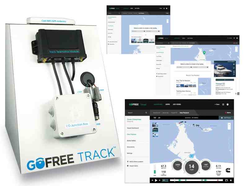
Navico, the company that makes Simrad and Lowrance electronics, debuted its first-of-a-kind GoFree Track in February at the Miami International Boat Show and plans to roll it out to market in July. The truly groundbreaking aspect of this service is that it allows boaters to connect to the cloud while aboard, using Wi-Fi, satellite or cellular signal.
Cellular connectivity extends the range of communication 10 miles or more offshore, says Phil Gaynor, Navico’s senior product manager for telematics. Boats that once could connect to the cloud near land, using a Wi-Fi hotspot, or anywhere worldwide via expensive and slow satellite service, can now affordably connect via cellular while fishing most coastal locations.
That might be welcome news to some, anathema to others. But take heart: GoFree Track was designed for vessel monitoring, not for Web surfing. This cell connection is different from your phone signal. It’s provided by the Navico partner Vodafone, which supplies similar machine-to-machine service to a wide variety of businesses throughout the world.
“There really isn’t any other system on a boat besides electronics that has the capability of bringing digital data into one place,” says Greg Konig, Navico executive vice president. “Telematics is going to make it easier for consumers to upload and download information.”
Konig points out that Navico was among the first companies to pioneer marine cloud-based services with its GoFree Insight Genesis system, which allows anglers to upload sonar logs to generate charts they can download to their MFDs.
“With Track, we’re trying to insert the vessel into the GoFree environment. In addition to mapping and sonar, we’re bringing the rest of the boat into the data,” Gaynor says.
That includes security-sensor data and information on up to five engines. Anything that can connect to an NMEA 2000 bus can also be reported, Gaynor adds.
Navico will sell Track — a black-box module with built-in Wi-Fi and GPS, along with an assortment of sensors for door entry, temperature and high-water levels — for under $1,000 (available in mid-2016). Initial cell subscription will be free for location services and alarms. Navico is also working with Iridium to use Track with the latter company’s Go! smartphone-connection hub.
“Typically, the value with telematics is around security and support services,” Gaynor says. “But we want to add the whole idea of social content too.”
As an example, a boat-rental company or anglers who share a vessel might want to provide a timeline of photos and activities to customers or owners. Using an app and a smartphone, an angler could record images and data, such as fish catches and weather, and upload it to a timeline through Track.
While Navico is first to bring this telematics system to market, other electronics companies appear to be following the same road by developing Internet connectivity and limited information transfer aboard vessels, initially via Wi-Fi. Most do not employ telematics yet, although Garmin has tapped into that technology within the automotive and fitness industries.
Garmin Connect, for example, allows runners, bikers and swimmers to upload, store, analyze and share fitness activities from their wrist-worn devices. Users can also download updates to those devices.
“We know that connectivity is quite important to mariners too,” says Carly Hysell, Garmin’s media relations manager. “Our Garmin Helm app lets you view and control a compatible chart plotter from a mobile device, and BlueChart Mobile has been used for years by our customers who want to plan and view routes from a mobile device, then transfer them to a plotter. We’ve also recently introduced the ability to wirelessly stream weather data overlaid onto a plotter screen.”
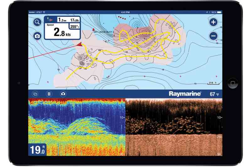
Raymarine too offers view and control apps to connect an MFD to a mobile device. In addition, the company works with Navionics’ SonarChart and SonarChart Live systems to record sounding data in real time and upload it to Navionics’ cloud service. Currently, the data transfers from the MFD to a smart device and then to the cloud.
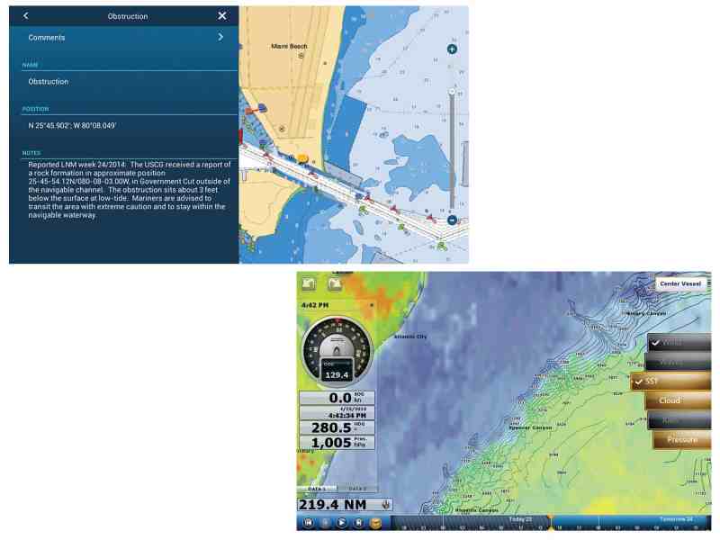
Raymarine MFDs can connect to the Internet via Wi-Fi hotspot to download software updates for all peripheral devices aboard. In January, a new software update, LightHouse 16, allowed anglers to back up data such as waypoints and routes directly from the MFD to the cloud.
Select Furuno MFDs connect to the Internet for software updates and free weather-related updates, including sea-surface temperatures, via its NavCenter. Soon, Furuno TZtouch2 units will dynamically show points of interest using Active Captain’s worldwide crowdsourcing database.
Humminbird‘s ION MFDs employ a built-in browser for Wi-Fi Web surfing, although they’re not set up for transferring files.
The Future of Onboard Communication: Signal K
On a final technical note: While current onboard communication between devices uses NMEA 2000 networking and similar connection protocols, a handful of boating-enthusiast developers have been working on a new system called Signal K.
According to the Signal K website, this is the next-generation solution for marine data exchange, not only for communication between instruments and sensors on board a single vessel, but also for sharing data between multiple boats, aids to navigation, bridges and marinas. Signal K “is designed to be easily consumable by Web and mobile applications and to connect modern boats to the Internet of Things.”
Better hold on to your handrail. It’s about to get interesting.


