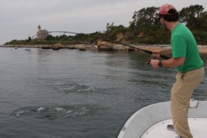
If you could briefly empty the oceans of water, a lot of fish would be unhappy, but: You’d see some amazing views of the submarine topography on our planet.
The good news is, we can leave the oceans full of water and still get some of those views, thanks to the 3D bathymetric navigation charts of NSI, Inc., which boasts the most complete, compressive and accurate bathymetric database for U.S. waters.
Mark Pringle, chief cartographer at NSI, has provided Sport Fishing enthusiasts with this exclusive, revealing gallery showing some of America’s best-known, most consistently productive hot spots, from Alaska to the Northeast.
Scroll through these images — and see what you’ve been missing. (If you’re seeing them on a mobile phone, remember to revisit these on a monitor where larger images will reveal more detail.)
Ed. note: The scales of distance you see on these 3d images are not accurate for all areas of the image. Due to the perspective of the 3D area pictured, the distance scales are relative to the lower center part of the image only or the area immediately adjacent to it, providing relative reference (but not accurate as a measuring tool).
CATALINA ISLAND
Sitting just under 50 miles from Los Angeles, Catalina Island is famed among anglers for a plethora of game fish including calico (kelp) bass, white seabass, yellowtail, giant sea bass (not legal to keep) and more including striped marlin and tuna in nearby blue water.

Charleston Harbor
This major deepwater port in South Carolina is also home to some excellent fishing, including huge bull redfish, as well as tarpon, cobia and blacktip sharks, depending upon one’s timing.

Eastern Gulf of Mexico Escarpment
Sure, the northern Gulf of Mexico is pretty well-known for a gradually sloping, flat, featureless bottom — until you move out into deeper water. At that point, things get really interesting in terms of relief and structure, as this contour map clearly shows.

Golden Gate Bridge Channel
The channel that runs beneath San Francisco’s famed Golden Gate Bridge offers anglers seasonal action for salmon, striped bass and california halibut as well as sturgeon, sharks and more. Fast-running tides and ship traffic require experience and caution.

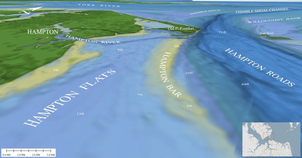
Hampton Bar
This narrow, shallow ridge north of Norfolk, Virginia, in lower Chesapeake Bay has long been a favorite of anglers for striped bass, cobia, flounder and other game fish.
Hudson Canyon
Located about 100 miles east of the New Jersey’s Hudson River, the Hudson is one of the world’s largest submarine canyons — and among the most productive for tuna (bigeye, yellowfin, bluefin), swordfish, marlin (whites and blues) and mako sharks.

Islamorada Hump
This small seamount sits about 15 miles off Islamorada in the Florida Keys. It’s popular for bluewater game fish and coastal pelagics (particularly blackfin tuna) as well.

Middle Ground
This 460-square-mile area of ridges rising off the otherwise smooth Gulf floor lies a bit more than 100 miles northwest of Tampa Bay. Though a long run from the coast, the area is well-known for big cubera snapper, large grouper and a great variety of fishes.

Midnight Lump
Located about 50 miles southwest of Venice, Louisiana, this salt dome rises from around 400 feet to within 200 feet of the surface and has long attracted dozens of boats on busy days vying for the hordes of tuna and wahoo that, at times, feast on bait fish over this structure.

Mississippi Canyon
While the Midnight Lump rises from 400 feet to 200, the amazing Mississippi Canyon nearby plummets from 400 feet to nearly 4,000 feet in places. This vast canyon averages about 5 miles wide; its walls may be home to swordfish feeding in the deep-scattering layer during the day.

Norfolk Canyon
About 70 miles off the mouth of Chesapeake Bay, this steep, deep, narrow canyon snakes its way into the Continental Shelf. It’s 35 miles long and more than a mile deep in places. Norfolk Canyon is a go-to area for many anglers targeting large tunas and other blue-water pelagics.

Possession Bar
An extension of the southern end of Whidbey Island in northern Puget Sound, the sheer walls of the bar help funnel currents up and over the top, where chinook salmon feed heavily, including resident fish called blackmouth locally, during winter months.

Resurrection Bay
Seward, at the head of this long inlet, is the primary jumping-off point for accessing Resurrection. It’s main claim to fishing fame is the typically bountiful run of silver salmon from midsummer until early September, though many halibut are caught toward the mouth, as well.

Stellwagen Bank
A short run from Cape Cod, Massachusetts, will put an angler on Stellwagen‘s southwest corner, a well-known and well-fished spot for bluefin tuna. The bank, part of a marine sanctuary, rises to about 65 feet at its shallowest and is about 6 miles across at its widest.

Strait of Juan de Fuca
About 100 miles long and up to 18 miles wide, this huge channel separates British Columbia from Washington, and connects Puget Sound with the Pacific. It is often windy and beset with thick fogs. Heavy currents pour in and out. But so do salmon and from Port Angeles out to Neah Bay, anglers work near the shore for salmon as well as halibut.

The Race
This waterway runs between Fishers and Gull islands at the mouth of Long Island Sound, south of New London, Connecticut. The huge currents that barrel in and out make fishing tricky but very productive for large striped bass on jigs or live eels. Bluefish and false albacore feed here seasonally, as well.


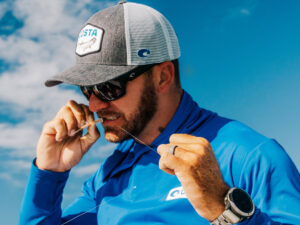
About the Author and NSI
In 1994, Mark Pringle, along with business partner Floyd Phillips, were fishing an offshore tournament. “We had every navigation and fishing chart available at the time — yet we quickly realized we had no real idea of what structure might lie beneath us.” Their engineering and business-management skills, along with knowledge of the marine market, led to formation of NSI. Today NSI, located in Edgewater, Maryland, has the most complete, compressive and accurate bathymetric database available for U.S. waters. More than a billion geo-referenced soundings from hundreds of sources allow tremendous resolution of images. NSI creates the Contour 3D bathymetric charts for Maptech, contributes to Navico’s Nautic Insight charts, and develops software for the U.S. government and many private clients.